Changes in spatial use as seen in the layout of castles and the development of town layouts
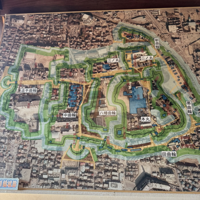
Kawagoe Castle is a flatland castle built in the mid-15th century by Ota Michizane, a warlord of the Muromachi period, and his son, Ota Dokan, a renowned castle builder. Ota Dokan is also known as the builder of Edo Castle, and his knowledge and experience were put to good use in the construction of Kawagoe Castle. The castle’s location cleverly combines the former course of the Irumagawa River with a tongue-shaped plateau, making use of the terrain itself as a natural fortress. The structure, which makes use of the moat and differences in elevation, combines high defensive capabilities with convenience as a governing base, and became the foundation for Kawagoe’s later development.
From the time it was first built, Kawagoe Castle functioned as the political, military, and administrative center of the region. During the Sengoku period, it came under the control of powerful daimyo such as the Hojo and Uesugi clans, and was repeatedly renovated and rebuilt while surviving repeated wars. In particular, during the time when the Hojo clan ruled the Kanto region, Kawagoe Castle was positioned as a key position in the northwestern part of Kanto, and played a part of the defense line to Edo.
Castle Town Development and Town Planning
During the Edo period, Kawagoe Castle became the residence of a fudai daimyo (feudal lord) of the shogunate, and its close ties with the Tokugawa clan led to the development of a stable castle town. In particular, during the reign of Matsudaira Nobutsuna (1644-1647), the castle grounds and townscape were significantly redeveloped from an urban planning perspective. Nobutsuna was a brilliant politician known as “Chie Izu,” and under his rule, Kawagoe developed into a modern city with a balanced focus on commerce, administration, and religion.
The town was laid out in a radial street structure with the castle at its center, which was not simply for the sake of transportation convenience, but also had a political purpose: to spread the power of rule throughout the town.On the southeast side, a commercial district for townspeople was formed, where merchants gathered and a lively market was held. On the northwest side, on the other hand, a samurai district was developed, with the residences of feudal lords lined up in an orderly fashion and serving as a defensive line for the castle. This urban structure is also highly regarded as a prime example of “urban planning that integrates control and defense.”
Town map of Kawagoe Castle town

Temple Belts and the System of Faith and Fire Prevention
One of the most distinctive features of Kawagoe Castle Town is its unique layout known as the “Temple Belt.” This system, which concentrated many temples between the castle and the townspeople’s area, served both as a practical firebreak and a spiritual barrier. Fires were a constant threat in castle towns during the Edo period, and the idea of using temples as a firebreak was a highly rational and deeply religious design.
This “temple belt” includes famous temples such as Myozen-ji, Kita-in, and Renkei-ji, which remain at the center of local faith and culture to this day. Kita-in, in particular, is famous nationwide as a temple associated with Tokugawa Iemitsu, and is a symbol of Kawagoe’s prosperity during the Edo period. The fact that temples are incorporated as part of the urban structure clearly demonstrates that Kawagoe was a “town where faith and governance coexisted.”
Former and Present Town Names
The correspondence between the town names of the time and those of today is essential to understanding the layout of the towns around Kawagoe Castle.
Comparison of old and new town names
| Honcho | Motomachi 1-chome Kitamachi Ohtemachi Saiwaicho |
| Kitamachi | Kitamachi Motomachi 2-chome Shidamachi |
| Takazawamachi | Motomachi 2-chome Kitamachi |
| Minamicho | Saiwaicho Suehirocho 2-chome Motomachi 1-chome・2-chome |
| Edocho | Ohtemachi Motomachi 1-chome Matsuecho 2-chome |
| Shidamachi | Shidamachi Kitamachi Miyashitacho 2-chome |
| Kajimachi | Saiwaicho Nakamachi |
| Tagacho | Saiwaicho Ohtemachi Miyashitacho 2-chome Nakamachi |
| Kamimatsuecho | Matsuecho 2-chome |
| Shigimachi | Nakamachi Matsuecho 2-chome |
Many of these town names remain today as place names and shopping street names, and walking around with an old map in hand, you can get a feel for the layout of the town at the time. Motomachi and Nakamachi in particular have been commercial centers since the Edo period, and together with their kura-zukuri streetscapes, they are symbolic areas of Kawagoe that attract many tourists.
Modernization and Preservation of Remains
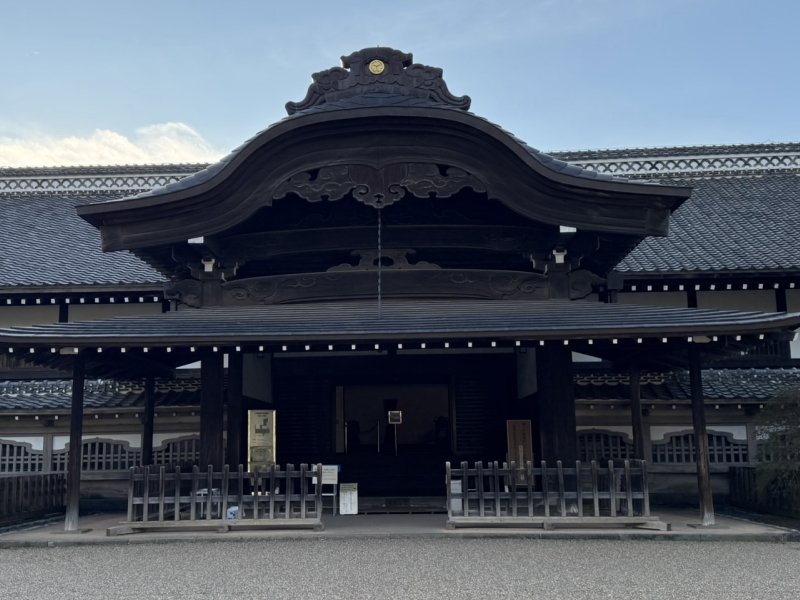
After the Meiji Restoration, amid a nationwide trend toward modernization, Kawagoe Castle’s samurai residences and portions of the castle grounds were lost. Fortunately, however, valuable remains, such as the Honmaru Palace, the remains of the Fujimi Tower, and the remains of the Nakanomon Moat, remain. These are important cultural assets that Kawagoe City is proud of, and a must-see for history buffs.
The Honmaru Palace is one of the few remaining castle buildings from the Edo period, and inside you can see exhibits that recreate the lifestyle of samurai and the political arena of the time. From the remains of the surrounding Fujimi Tower, you can get a panoramic view of the city and distant mountains, allowing you to imagine the scale and grandeur of the castle from long ago.
Additionally, Ichibangai (storehouse-style street), once a townspeople’s area, is known for its rows of fire-resistant earthen storehouse-style buildings. The landscape of black plaster walls and heavy tiled roofs is exactly why Kawagoe is called “Little Edo.” Even after experiencing the great fire of the Meiji era, residents continued to preserve the traditional style, creating the townscape we see today.
Memories of “Dominion and Space” Remain in the Present
Kawagoe is not simply a historical city; the space where “dominion,” “faith,” and “life” overlap constitutes a historical record in itself. The town layout, centered around the castle, the temple belt that combined fire prevention and religious services, and the townspeople’s neighborhoods where commerce and culture coexisted—these elements are intricately intertwined, and traces of these intertwining events remain with us today.
When you walk through modern-day Kawagoe, you will notice that although it appears to be a bustling tourist destination, the intentions of the past quietly live on in the streets, topography, and layout of buildings. If you stroll through the town while learning about its history, you will be able to get a real feel for how Kawagoe has combined “control” and “spatial composition” and has inherited this structure to the present day.